Following in the footsteps of Alfred Wainwright really appealed to me, mainly because it would not only be a challenge to myself to visit all 214 mountain summits on his list, but it would also be a fantastic journey, and great way to see all of this wonderful national park, and put me into places I wouldn’t normally get to.
I already had two summits on Alfreds list already done, so my plan of action was to start with the horseshoe walks first. Climbing one initial mountain and walking the summits linked, usually in a u shape, will enable me to visit a few summits in one day, thus giving me a bit of a start.
Still improving my kit I purchased a drinks bladder to save me stopping to take my rucksack off every time I need a drink.
And I also bought a GPS for a bit of added security. I would be walking in all weathers in the future, in unfamiliar terrain and although I have map and compass and know how to use them, I felt it would be useful to confirm my position when I felt the need to by a reliable waterproof unit, plus track my route and have an altimeter to refer to for a reference.
Today would be a first for me. whenever I have gone to the Lakes, I’ve stayed in b&b’s, cottages hotels etc with my wife. But today I was going to drive to the Lake District, do a classic walk and drive home on the same day. About 2.5 hours drive each way, so a long day in store.
Having done a little homework on various walks, I chose the Coledale Horseshoe, this had nothing too technical to climb and would include Grisedale Pike, Hopegill Head, Crag Hill, Sail, Scar Crags, Causey Pike, Outerside, and finally Barrow. 8 summits in a u shaped valley of 10.4 miles.
A tough first Horseshoe, but I don’t think any are easy.
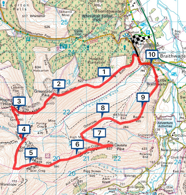

The Coledale Beck runs down the valley joining up with the Newlands Beck before flowing into the nearby Bassenthwaite Lake
The disused mine of Force Crag sits at the head of the valley, and was used to mine lead and silver back in the 1800’s.
It’s now owned by the National Trust after the mine collapsed in 1990.
I was starting from the little village of Braithwaite, parking just off the Whinlatter Pass with only room for about six cars. So I needed to be there early, and planned to be there for 9am. This meant leaving home at 6.30am allowing a loo stop on the way.
I was packed and ready the night before with just food and drink to take out of the fridge in the morning, so after a quick shower I left pretty much on time.
The M6 was quiet which gave me a good run north, the sun was out, and it was looking like a good day ahead.
The views of Blencathra and the Coledale Round as I drove down the A66 was fabulous, especially Grisedale Pike knowing I was about to climb it. I was buzzing with excitement and couldn’t wait to get there.
I arrived in the village of Braithwaite on time but I was still the third car to park up in the small car park, as it turned out there was plenty of roadside parking as well so I needn’t of worried.
Not knowing what to expect of the day, how hard it would be, I had a brew and a banana to fill the energy levels up while I got to grips with my GPS resetting mileage distance before heading out.
Straight from the car park, I’m greeted with steps up onto a winding steep path, snaking through greenery.
This initial climb up was brutal, with no time to warm the leg muscles. In absolutely no time at all I was looking back down over Braithwaite village, hot and breathless already!!! This was a tough start to the day.


Looking across the meadows east from above Braithwaite, The Skiddaw range

The steep slopes by Hospital Platation

A great view looking down on Braithwaite village
After the initial steep ascent, I was soon on Kinn 374m and my newly acquired fancy GPS confirmed it. This is where the climb plateaus out for a brief spell and gave me a chance to catch my breath and look out to the Skiddaw range to the east, and the Whinlatter Forest to the north before looking at Sleet How in front of me, towering above. I could also see most of the days walk ahead as I ploughed on up Sleet How in the June sunshine. It was a two mile slog to the summit and the last section was the steepest part on the well established path. Never had my boots been so dry but dusty in all my walking in the Peak District.


Kinn, it's path snakes from left to right up to the summit of Grisdale Pike.

Weighing up the afternoons mountains of Causey in the distance, Outerside and Barrow

The Grisedale grind

Another shot of the Skiddaw range and Blencathra beyond

The final steep slog to Grisedale Pike summit
Finally I had ascended Grisedale Pike and all of it's 791metres, my first summit of the day, and to be honest I was feeling it. It was only about 11am but I sat down and looked across at the other side of the Horseshoe. Causey Pike, Sail, and below them the little chocolate box of Outerside, and I wondered if I’d have the energy to do them all.

Having looked up many times from Keswick, I was now looking down from Grisedale Pike.

Sat on Grisedale Pike summit, looking at the green Outerside and Causey Pike beyond
Funny though, after a few minutes gazing at Keswick and the surrounding mountains in beautiful sunshine, I had recovered, and ready to carry on. Eyeing up Hopegill Head and the rock face of Hobcarton Crag in the distance, my next waypoint.


I'm going that way. Eel Crag (left) Grasmoor (Centre) Hopegill Head (Right)

My next waypoint, Hopegill Head

It was a nice easy walk from Grisedale Pike down the well trodden path, and great views northwards could be seen along it with Whinlatter and the surrounding forest not far away. Looking over to the other side of the Horseshoe to the southeast I was able to weigh up my afternoon walking on Sail, Scar Crags and Causey Pike.
Hopegill Head was soon reached, and a great view down the ridge to Whiteside could be seen, one for another day I think.
The weather had turned a bit, cloud was forming with rain forecast later in the day.


View of the ridge from Hopegill Head to Whiteside, and just picking out Crummock water.
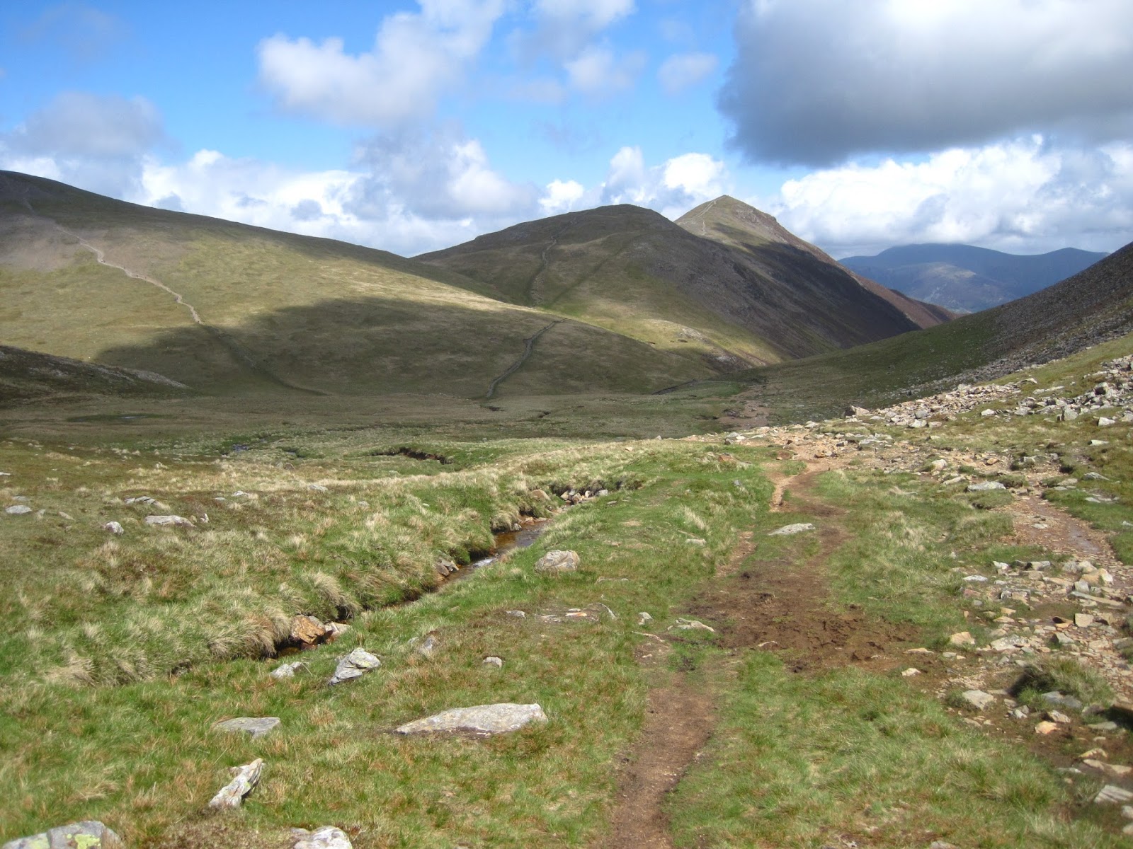
I was now heading over Sand Hill, down to Coledale Hause where I stopped by Liza Beck for a bite to eat.
Here by the stream, I removed my boots and socks for a dip in the cold flowing waters.
I always find it refreshing dipping my feet during a walk, even changing socks helps to freshen them up.
I always find it refreshing dipping my feet during a walk, even changing socks helps to freshen them up.
The GPS seemed to be working well and really pleased with its performance so far, showing I'd covered just over three miles, and the altimeter looked pretty accurate.


Hillsides running into Coledale Beck

Selfie on Sand Hill

Looking back down the Horseshoe from Coledale Hause
My second stop, just after mid-day and a dip here in Liza Beck. Grisedale Pike is the far peak in the background
Energised after a drink and snack, my freshly washed feet were rejuvenated, so I left the Coledale Hause behind as I made the gentle climb up to a well defined crossroads.
If I carried straight on, I’d be heading down into Buttermere. Some walkers will turn right here, and include Grasmoor in the Horseshoe walk, before returning back to this point to carry on.
Not me, Grasmoor will be one for another day. I felt what I was already doing today was enough. So I’m turning left up the steep grassy hill to Crag Hill 839m the highest point of the day.
I felt quite pleased with myself here at Crag Hill, I felt good, and from here I was heading back towards Braithwaite, I was over halfway around having passed 5 miles with three Wainwright summits in the bag I still had five to go, but I’d covered the toughest part of the day and felt confident, plus although cool, the sun was back out again.


Trig point on Crag Hill
I met a guy on the summit here, we had a chat and he snapped a photo of me at the summit. He then began telling me of all the walks he’d been on recently in Yorkshire. I was interested, but at the same time a little aware of the time ticking on, so I made my excuses and headed towards Sail.


The path from Crag Hill to Sail is narrow, but nothing to worry about. Views out to the south to the nearby ridge of Knott Rigg and Ard Crags are superb. The stunning Newlands Valley and Buttermere beyond, over looked by Red Pike, High Stile and High Pike.


Simply Sail
The passage down from Sail can not pass without mentioning the snaking path down to Scar Crags, I have got to say it looked a totally unnatural mark on the landscape, raised off the hillside, I only hope in time the view from Scar Crags to Sail isn’t a permanent scar and the path blends in.


Not the best shot of the Sail path, but a scar none the less

A shot of the Buttermere fells of High Crag, High Stile, and Red Pike. Buttermere Moss to the left of photo, and Sail Beck in the valley below, which runs into Crummock Water.

The Newlands fells and Knott Rigg in the foreground

Ard Crags

Rigg Screes

Rigg Beck, running between Rigg Screes and Scar Crags
The walk to Causey Pike was steady and really enjoyable, appreciating the surrounding views after negotiating the humps leading to the summit cairn at 673m.
From here excellent scenery of Keswick, Derwent Water and it’s sailing boats, the Newlands Valley, the Skiddaw range, Blencathra the Helvellyn range, oh I could go on.......and I do but It was just stunning.


Causey Pike summit

I could now see the old lead mine at the head of Coledale Beck, and Force Crag.
It had been a long day already, Outerside and Barrow were options I could opt out of if I’d run out of steam. Looking down from Causey Pike, Outerside looked tiny.
No problem I thought, easy....A path not on the map took me directly down to meet the path from Sail. As I descended off the ridge, looking over, Outerside just got bigger and bigger. By the time I was at the foot of the fell, I really had to dig deep into my reserves to keep going, I was determined to summit all eight fells. Once at the summit of Outerside at 568m it was a relief to see the going ahead was easy, and it was apart from a bit of bog near Barrow 455m.


Outerside summit

view of Grisedale Pike from Outerside

Looking back at Outerside

Beautiful views as I walk to Barrow summit

Barrow summit ahead

Looking back at the days walking

Barrow summit
It’s a steepish descent down to Little Braithwaite and the farm from Barrow, tough on my knees, so I was glad to be back down on the flat of the farm track after passing through the farm and into the village, where I went slightly wrong navigating my way back to the car.
I passed the Royal Oak pub, and as you’d expect on a lovely Summers afternoon a few drinkers were stood outside having a good old chin wag and laughs.
I was driving of course, a long one at that, so I resisted the temptation to join them.
This is one of the down sides to a solo walk. Not being able to share the days experience over a well earned pint.


I arrived back at the car about 5pm, tired, aching but satisfied. I’d throughly enjoyed the ten mile walk. The weather had been perfect, and I don’t think I could have chosen a better first Horseshoe route. I was planning the next trip before I arrived home safe and sound.
10 Wainwright’s done, just 204 to do, but I’m up for it.