It was mid November, and I had the opportunity to stay overnight at a cottage in Ambleside, when family members vacated the cottage they were staying in after seeing the village's Christmas light switch on over the weekend, which is quite an event, with street procession, fireworks and Santa illuminating the streets by sprinkling his.......erm magic dust to finish.
This opportunity allowed me to arrive in Langdale early Monday morning, without getting up at stupid o clock, for a long night drive north.
Driving to the Lake District on a quiet Sunday afternoon, on my own without the pressure of finding a parking space at the other end of the journey before a walk, was a nice change to the usual. The family had now vacated the cottage and were on their way home, leaving me to settle in for the night with a beer or two along with pizza.
 Ambleside's Christmas lights viewed from the cottage
Conditions in the Lake District were dry and free of snow, so a good walk over a hand full of summits was on the cards.
My plan was to get into the Langdale Valley before dawn, parking at the Old Dungeon Ghyll Hotel, before heading out west along the Cumbria Way, heading for Rossett Pike, using the old zigzag pony route. then onto Allen Crags, Great End, Esk Pike and if daylight allows, Bowfell, returning down ‘The Band’ which should be a little over 10 miles.
I chose anti clockwise because all but Bowfell would add to my Wainwright list of 125.
if I had little daylight left after Esk Pike, or just ran out of steam, I could bail out at ‘Ore Gap’ leaving Bowfell, and head down to Angle Tarn and return on the now familiar route back.
 The planned route and mileage
Monday's weather forecast was reasonably good for this time of year, although overcast with the possibility of occasional snow flurries, the cloud base was expected to be above all summits with temperatures just above freezing at summit height.
However a strong north westerly wind was expected to blow in at around 40 to 50 mph at times, so it was going to be cold and breezy.
After a less than perfect nights sleep back in Ambleside, I was late leaving the cottage.
As always, my gear took longer to pack, and locking up the cottage took even longer.
I arrived at the ODG car park in the Langdale Valley just after 8 am, after driving the 20 minutes from Ambleside in the low light of dawn.
As a National Trust member, parking is free here, and as you’d expect on a winters Monday morning, the car park was almost empty.
I was wearing a 'Fitbit' tracker today for the first time on a hike. This measures steps taken, heart rate, calories burned etc, so I was interested to see what kind of stats it would reveal from the days activities.
With GPS set, or so I thought, and rucksack firmly in place I was finally walking along the Cumbria Way by 8.15 am heading west in eager anticipation of an excellent day ahead.
It’s quite a long flat walk along the valley from the Old Dungeon Ghyll car park to the bridge which would take me across Mickleden Beck, walking a firm stoney farm track towards the mountain slopes.
 Leaving the Old Dungeon Ghyll Hotel heading west on the Cumbria Way
 'The Band' seen from the Cumbria Way
 Gimmer Crag and Pike of Stickle
This first section of walking gave my old legs a good chance to stretch and warm up before the climb ahead, which was staring down at me in quite an intimidating way.
Being in the valley, the NW wind didn’t feel too bad, but the air felt cool and fresh.
Walking along Mickleden Beck, the rock faces of Gimmer Crag and Pike of Stickle were bearing down from the right. To the left of the track, I could see my possible return route down ‘The Band’ from Bowfell.
Ahead of me was Rossett Crag and Black Crags of course, this was my intended route. Climbing steeply up to Rossett Pike, Alfred Wainwright described this climb as “Tedious and stony”. It looked quite steep from the valley floor, but in all truth, once on it, it would be fairly easy going. The rest of my route although higher still, was beyond the view I had.
One bonus walking along the valley floor, was the high crags all sheltering me from the wind.

Following The Cumbria Way towards Rossett Crag, my route would take me up to the col on the the left, before the final section to Rossett Pike summit (right of col)
 Looking back along the Cumbria Way towards Great Langdale
I’m not a big fan of night-time navigating in the mountains, and especially in the winter months, probably due to a lack of time and experience walking in the hills at night.
So I try to keep it to a minimum, knowing a route will be tight on daylight hours, I will make a rough calculation of times and where I should be during the day on paper. This schedule then allows me to decide if I have time or not later in the day to complete the route or not, avoiding any tricky route finding in the dark. It’s not a time I’m conscious of trying to keep to, that would reduce the pleasure of the day and make it a race against time. No it is purely for easy reference to my progress during the day. However this does show if I need to pick the pace up if I decided to commit to my original route or if conditions or circumstances changed for the worse.
I figured it would take about 45 minutes to arrive at the bridge crossing Mickleden Beck from ODG, and I was pleased to arrive at the bridge pretty much on time, which was a good start.

Crossing the bridge over Mickleden Beck, a couple of fell runners came passed me heading towards Rossett Pike, and gave me a polite nod. Walkers or runners would be few and far between during the day, and as I made my way up this old smugglers route, following them at my more modest pace, they were soon out of sight, and once again, I had the mountains all to myself.

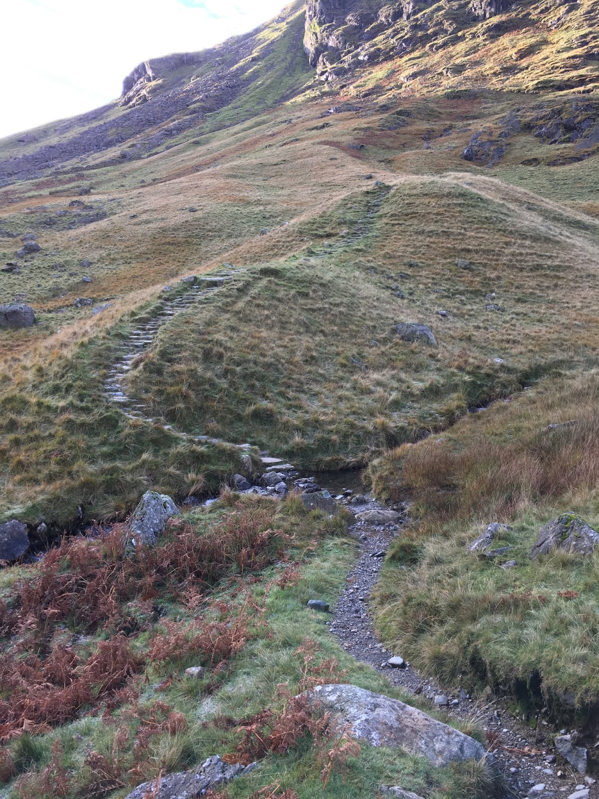
 The start of the climb up to Rossett Pike
This part of the climb, although stoney, it was a well constructed path with lots of steps, with a zigzag course that takes out much of the steepness. It made the walking slow but it was steady, passing over a layer of pinkish coloured rock in the higher reaches of the fell.
While negotiating this section, I would stop for the odd breather, while looking back behind me, at the now excellent views opening up of Mickleden below, and the surrounding peaks.
 A brief change in colour
Again I’d allowed just over an hour from the bridge to my first summit of the day, and It was looking good. I could now feel the wind picking up as I gained height, and no longer had the crags protecting me from the west.
The final ascent to Rossett Pike from the pony track route is marked by a large cairn. Turning right at this point allows for the short and easy walk, mainly on grass, up to the rocky summit.
 The cairn indicating the right turn up to Rossett Pike. Allen Crags, and Great End's peaks popping up in the far distance.
From here at the cairn though, I could weigh up my route to Allen Crags, dropping down the other side of Rossett Pike’s flanks to Angle Tarn, then a climb to Allen Crags, higher still was Great End, looking west was Esk Pike and my possible bailout route, Ore Gap.
But for now, the summit of Rossett Pike was calling. It’s always nice to reach the first summit of the day, as it’s usually the longest climb and hardest earned, and Rossett Pike was no exception to this general rule.
 View of Rossett Pike summit from the cairn
Rossett Pike has a small ridge formation dropping from the 651 metre summit, to a lower cairn a few metres further on along the ridge, with Rossett Crags below. I thought it was worth a wander down for the excellent views down to Mickleden, the Langdale Valley in the far distance and surrounding fells, and it was worth it.
 Looking back down to Mickleden and the route I've followed so far, viewed from Rossett Pike. Pike of Stickle is seen on the left. The Band on the right.
 Pike of Blisco (centre) seen beyond The Band.
It was now as windy as hell, and my balance was almost lost a couple of times as I wobbled back, returning to the summit before heading down the grass slope of the north side of the peak, regaining the pony route heading down to Angle Tarn.
 Rossett Pike summit 651m
The temperatures felt a little milder than forecast when out of the wind, but the wind speed forecast was probably spot on, making it a pretty chilly day.
As I made my way up towards Allen Crag. I noticed the Esk Hause junction first, this is about 100 m higher than Rossett Pike. Here a crisscross of paths merge from Sty Head, Great End, Esk Pike, Allen Crags and of course Rossett Pike. Here a wind shelter provides the perfect spot to stop, and although it was only just gone 11 am I decided to grab a bite to eat and drink here, as it was such a good spot. Although I intended to push on to Allen Crags first, I needed a break from the wind as it felt so cold.
Taking my gloves off just to take a photo or eat a sandwich was now uncomfortable, so I was quick to get them back on after retrieving a sandwich from my pack.
 The shelter at Esk Hause
It was at this point, while just looking out from this shelter at the col, that two fighters on a training exercise, I would presume, flew straight passed me from the NW into the Langdale Valley. I did manage to capture one of them, albeit at some distance as it took time to get those blumin gloves back off with cold hands, and unfortunately those jets weren’t hanging around.
 The jet fighter seen centre of photo from the shelter
Having topped up my energy levels, I slipped my rucksack back on, gloves in place, and pushed on to Allen Crags about half an hour behind my pencilled calculations, a very short stony path winds up to the summit cairns. Again excellent views out to the north looking at ‘Glaramara’ along the undulating ridge. High Raise and Ullscarf to the NE. Keswick can be seen from here too. Dominating the view NW is Great Gable.
But unfortunately I was being severely buffeted by the wind here, struggling to take a steady photo, in the biting wind, so my stay was cut short, as I retreated back down for some protection back at the ‘Hause’
 The short climb to Allen Crags from Esk Hause
 Allen Crags summit 785m
 Looking north towards Glaramara. Derwent Water and Keswick can be seen in the distance.
The route I was taking up to Great End is usually a busy one, with many Scafell walkers using this route, but it was pretty quiet today, as I made my way up to Calf Cove. It was here the couple of runners I met down in the valley below passed me again, this time descending presumably from Scafell Pike.
 Climbing Great End
I reached the windy 910 m rocky summit of Great End just after midday, touching both cairns, not being totally sure which was the true summit. At a little under three thousand feet, Great End would be the highest point of the day.
I could see the summit construction on Scafell Pike just over a mile away, so close, but it didn’t look an easy mile. No quick there and back, but it did cross my mind for a few seconds to go for it.
But knowing I still had a good way to go back to Langdale, via Esk Pike and possibly Bowfell, about 6 miles, adding any more mileage to the day at this point, in these windy conditions would be unwise.... for me anyway. I had a route planned for Scafell Pike, which included Lingmell, so I was happy to leave it for another day.
 Looking SW to Scafell Pike from Great End
 Looking down at Wasdale Head, Lingmell to the left and much of the Mosedale Horseshoe on show including Kirk Fell (right) and Yewbarrow, Red Pike and Pillar in the distance.
I stood admiring Great Gable from the summit of Great End for a short time, barely able to stand at times, as gusts of wind were still strong.
It’s extremely rare I get annoyed about anything on a day like this, but I had a rucksack strap-end that had caught me in the cheek twice with a whipping motion, while looking right and continued flapping in the wind. This had threatened to happen earlier, my fault of course, I forgot to fix it when I stopped.
 Great Gable and Green Gable separated by Windy Gap and Styhead Tarn at it's foot.

I headed back down to Calf Cove, backtracking until I reached Esk Hause again.
From here, Esk Pike looked an interesting fell, lots of rocks to negotiate and it didn’t disappoint. By the time I arrive at the rocky cairn summit, I was ready for a short stop.
But then the flapping rucksack strap finally caught me in the eye, what can I say apart from, I should have secured it earlier.
 Esk Pike and Bowfell ahead
 The formidable eastern crags of Scafell Pike
 Looking back at Esk Hause and Allen Crags in sunshine from Esk Pike
 Sharp rock formations on Esk Pike


 Esk Pike summit 885 m
It was just after 1 pm when that wind finally got the better of me. While my foot was wedged momentarily between some of the sharpest rocks I’d seen and felt all day, I lost my balance, and partially fell over, narrowly avoiding a bang on the head. Luckily no harm done, but it was a ‘what if’ moment. There was no one on the mountain but myself, that I could see, I try to be as careful as possible, but there is always a small risk climbing amongst rocks, especially walking on your own, and especially in winter when the mountains are quieter. Any help may not be at hand for some time. It certainly focused my mind again anyway.
 Looking at Bowfell from Esk Pike
After a much needed break and drink, perched behind a rock for shelter, it was time to push on down to Ore Gap, although this was my optional bailout route down to Angle Tarn, it wouldn’t shave much mileage off the return route to the car, it just meant I wouldn’t need to climb Bowfell, and then navigating the slightly trickier route down ‘The Band’ potentially in the dark.
But I felt fit and well, I'd made good time so far. I reckoned it was less than an hour from Esk Pike to Bowfell summit, putting me on Bowfell summit for around 2pm.
That would give me plenty of time to return via ‘The Band’ before darkness.
 Looking south from Esk Pike
 Bowfell from Ore Gap
It was the first time for me, climbing Bowfell from Ore Gap. The route was on a nice easy gradient, on a good path part way up, before giving way to a line of cairns to guide walkers through a boulder field, should you find yourself in mist heading to the summit.
As the afternoon drew to a close, the wind finally started to ease on the tops, and a pleasant scenic view could be admired now without having to brace for those annoying gusts.
A little bit of scrambling was required to gain the rocky summit of Bowfell, at 902 m. Amazingly Great End stands about 2.5 miles away but there is only about 7 metres between them in height.
 Last bit of scrambling on to Bowfell summit
Here on the summit sat, I presumed to be father and young son, admiring the fantastic panoramic views. It felt a little awkward hanging around after saying hello, as the pair weren’t going anywhere soon, so I quickly descended back down to the shelf below, latching onto the cairns heading SE, passing by the top of the ‘Great Slab’ on my way down to ‘Three Tarns’
 Pike of Blisco in sunshine, Windermere (top left)


As I made my descent off Bowfell, the rays of mid afternoon sun brushed the tips of the nearby Langdale peaks, the clouds giving way to blue skies.
The silence from the now calming air was only broken by the dry stone crunching from my boots, and an annoying squeak from my rucksack, as I dipped into shelter from the breeze.
‘Three Tarns’ indicates my turn east and down ‘The Band’ the route south continues up to Crinkle Crags, one I’ve only descended.
There were only actually two small pools of water here today at 'Three Tarns', maybe not a lot of rain recently? I continued my descent now heading east back down towards Great Langdale.
 The route down to 'Three Tarns' on Bowfell
This was indeed the best part of my day, my memory was full of the days mountain vistas, and my body was tired but full of satisfaction, I’d achieved my modest goals and thoroughly enjoyed every minute.
I’m not sure why, but days like this give me the feeling of enormous well-being, just the tonic for some of the down sides to coping with Crohn’s Disease, and everyday life in general.
It was a familiar descent for me down ‘The Band’ a long sloping spur that gently lowers walkers back into the Langdale Valley at Stool End farm.
With the sun slowly setting, I passed through the busy farm, up the lane, only to be welcomed by a flock of sheep, before joining the tarmac road for the last few minutes of the walk to the Old Dungeon Ghyll Hotel, arriving back at 4.20 pm.
 The Langdale Pikes seen from 'The Band'
 Great Langdale
 Stool End farm sits at the foot of The Band

My welcoming party
 Looking back at Stool End Farm
 Back at the The Old Dungeon Ghyll
Unfortunately I didn’t reset my GPS properly at the start of the day, so I didn’t get an accurate mileage reading.
However, my Fitbit recorded the days efforts, which I found interesting.

Once again an excellent day with some staggeringly beautiful views in all directions. a bit windy at times but the visits to four new summits was worth it. an absolutely unforgettable experience, and my Wainwright journey takes me to 129.
All that was left for me to do, was make the two hour drive home, stopping only for a Burger King at Lancaster's M6 service station, before joining the industrial wheel again the following day......
Driving to the Lake District on a quiet Sunday afternoon, on my own without the pressure of finding a parking space at the other end of the journey before a walk, was a nice change to the usual. The family had now vacated the cottage and were on their way home, leaving me to settle in for the night with a beer or two along with pizza.

Ambleside's Christmas lights viewed from the cottage
Conditions in the Lake District were dry and free of snow, so a good walk over a hand full of summits was on the cards.
if I had little daylight left after Esk Pike, or just ran out of steam, I could bail out at ‘Ore Gap’ leaving Bowfell, and head down to Angle Tarn and return on the now familiar route back.

The planned route and mileage
However a strong north westerly wind was expected to blow in at around 40 to 50 mph at times, so it was going to be cold and breezy.
After a less than perfect nights sleep back in Ambleside, I was late leaving the cottage.
I arrived at the ODG car park in the Langdale Valley just after 8 am, after driving the 20 minutes from Ambleside in the low light of dawn.

Leaving the Old Dungeon Ghyll Hotel heading west on the Cumbria Way

'The Band' seen from the Cumbria Way

Gimmer Crag and Pike of Stickle
Ahead of me was Rossett Crag and Black Crags of course, this was my intended route. Climbing steeply up to Rossett Pike, Alfred Wainwright described this climb as “Tedious and stony”. It looked quite steep from the valley floor, but in all truth, once on it, it would be fairly easy going. The rest of my route although higher still, was beyond the view I had.
One bonus walking along the valley floor, was the high crags all sheltering me from the wind.

Following The Cumbria Way towards Rossett Crag, my route would take me up to the col on the the left, before the final section to Rossett Pike summit (right of col)

Looking back along the Cumbria Way towards Great Langdale
So I try to keep it to a minimum, knowing a route will be tight on daylight hours, I will make a rough calculation of times and where I should be during the day on paper. This schedule then allows me to decide if I have time or not later in the day to complete the route or not, avoiding any tricky route finding in the dark. It’s not a time I’m conscious of trying to keep to, that would reduce the pleasure of the day and make it a race against time. No it is purely for easy reference to my progress during the day. However this does show if I need to pick the pace up if I decided to commit to my original route or if conditions or circumstances changed for the worse.


The start of the climb up to Rossett Pike
While negotiating this section, I would stop for the odd breather, while looking back behind me, at the now excellent views opening up of Mickleden below, and the surrounding peaks.

A brief change in colour

The cairn indicating the right turn up to Rossett Pike. Allen Crags, and Great End's peaks popping up in the far distance.
From here at the cairn though, I could weigh up my route to Allen Crags, dropping down the other side of Rossett Pike’s flanks to Angle Tarn, then a climb to Allen Crags, higher still was Great End, looking west was Esk Pike and my possible bailout route, Ore Gap.
But for now, the summit of Rossett Pike was calling. It’s always nice to reach the first summit of the day, as it’s usually the longest climb and hardest earned, and Rossett Pike was no exception to this general rule.

View of Rossett Pike summit from the cairn
Rossett Pike has a small ridge formation dropping from the 651 metre summit, to a lower cairn a few metres further on along the ridge, with Rossett Crags below. I thought it was worth a wander down for the excellent views down to Mickleden, the Langdale Valley in the far distance and surrounding fells, and it was worth it.

Looking back down to Mickleden and the route I've followed so far, viewed from Rossett Pike. Pike of Stickle is seen on the left. The Band on the right.

Pike of Blisco (centre) seen beyond The Band.

Rossett Pike summit 651m
The temperatures felt a little milder than forecast when out of the wind, but the wind speed forecast was probably spot on, making it a pretty chilly day.
As I made my way up towards Allen Crag. I noticed the Esk Hause junction first, this is about 100 m higher than Rossett Pike. Here a crisscross of paths merge from Sty Head, Great End, Esk Pike, Allen Crags and of course Rossett Pike. Here a wind shelter provides the perfect spot to stop, and although it was only just gone 11 am I decided to grab a bite to eat and drink here, as it was such a good spot. Although I intended to push on to Allen Crags first, I needed a break from the wind as it felt so cold.
Taking my gloves off just to take a photo or eat a sandwich was now uncomfortable, so I was quick to get them back on after retrieving a sandwich from my pack.
Taking my gloves off just to take a photo or eat a sandwich was now uncomfortable, so I was quick to get them back on after retrieving a sandwich from my pack.

The shelter at Esk Hause

The jet fighter seen centre of photo from the shelter
But unfortunately I was being severely buffeted by the wind here, struggling to take a steady photo, in the biting wind, so my stay was cut short, as I retreated back down for some protection back at the ‘Hause’

The short climb to Allen Crags from Esk Hause

Allen Crags summit 785m

Looking north towards Glaramara. Derwent Water and Keswick can be seen in the distance.

Climbing Great End

Looking SW to Scafell Pike from Great End

Looking down at Wasdale Head, Lingmell to the left and much of the Mosedale Horseshoe on show including Kirk Fell (right) and Yewbarrow, Red Pike and Pillar in the distance.
It’s extremely rare I get annoyed about anything on a day like this, but I had a rucksack strap-end that had caught me in the cheek twice with a whipping motion, while looking right and continued flapping in the wind. This had threatened to happen earlier, my fault of course, I forgot to fix it when I stopped.

Great Gable and Green Gable separated by Windy Gap and Styhead Tarn at it's foot.

From here, Esk Pike looked an interesting fell, lots of rocks to negotiate and it didn’t disappoint. By the time I arrive at the rocky cairn summit, I was ready for a short stop.
But then the flapping rucksack strap finally caught me in the eye, what can I say apart from, I should have secured it earlier.

Esk Pike and Bowfell ahead

The formidable eastern crags of Scafell Pike

Looking back at Esk Hause and Allen Crags in sunshine from Esk Pike

Sharp rock formations on Esk Pike


Esk Pike summit 885 m

Looking at Bowfell from Esk Pike
But I felt fit and well, I'd made good time so far. I reckoned it was less than an hour from Esk Pike to Bowfell summit, putting me on Bowfell summit for around 2pm.

Looking south from Esk Pike

Bowfell from Ore Gap

Last bit of scrambling on to Bowfell summit

Pike of Blisco in sunshine, Windermere (top left)


The route down to 'Three Tarns' on Bowfell

The Langdale Pikes seen from 'The Band'

Great Langdale

Stool End farm sits at the foot of The Band

My welcoming party

Looking back at Stool End Farm

Back at the The Old Dungeon Ghyll

All that was left for me to do, was make the two hour drive home, stopping only for a Burger King at Lancaster's M6 service station, before joining the industrial wheel again the following day......


