My first ever experience of a weekend stay in a hostel was about to happen, I was meeting up with a dozen walkers, to explore some of the beauty of Snowdonia over two days.
The Saturday walk had already been decided. This would be a walk from our accommodation, straight up the peak of Y Garn at 947m and then onto Glyder Fawr and Glyder Fach.

The only guy I’d walked a number of times with was Shaun, but unfortunately he couldn’t make the weekend at the last minute due to a house move. I had met about half the group briefly on different walks but didn’t really know any of them.
The Saturday walk had already been decided. This would be a walk from our accommodation, straight up the peak of Y Garn at 947m and then onto Glyder Fawr and Glyder Fach.

Saturday's route
The only guy I’d walked a number of times with was Shaun, but unfortunately he couldn’t make the weekend at the last minute due to a house move. I had met about half the group briefly on different walks but didn’t really know any of them.
We were staying in the Yr Hafod activity centre in the heart of the Ogwen Valley, Snowdonia, Wales.
Ruth was the organiser and she had arranged the booking for our “Walking forum” group exclusively from Friday to Sunday with all of us paying an equal share of the cost to Ruth before hand. The centre isn’t staffed, so the group were responsible for the building during our stay.
Friday evening
Ruth was the organiser and she had arranged the booking for our “Walking forum” group exclusively from Friday to Sunday with all of us paying an equal share of the cost to Ruth before hand. The centre isn’t staffed, so the group were responsible for the building during our stay.
Friday evening
I headed to Wales late Friday afternoon feeling a little nervous. I’d never done anything like this before and I was definitely out of my comfort zone.
When I arrived at the slightly remote centre after a two hour drive, I'd just parked up, and a cow just came walking through the car park all very casual like.

Once inside the centre a few guys were already there, and gathered in the main open planned communal room and kitchen. Which were full of conversations, laughing and plenty of banter could be heard around an extremely large dining table.

Once inside the centre a few guys were already there, and gathered in the main open planned communal room and kitchen. Which were full of conversations, laughing and plenty of banter could be heard around an extremely large dining table.
Some of the group had extended the weekend by adding a walking day on the Friday and Deb’s was particularly pleased to have climbed Tryfan’s North Ridge, guided by the more experienced Nathan.
It was a very friendly atmosphere and clear a number of folk knew each other presumably from previous meetings.
Most of the group had bagged their bunk beds for the weekend and unpacked food in the kitchen earlier.
I duly introduced myself to those of the group I’d not met before. And said a warm hi to those I had already met before.
After unpacking, I sat around the table taking the situation in and introducing myself to the last couple of arrivals.
We had all come together from all over the country. Deb’s and David were from London. Jon was from the southwest of England. Graeme from Stirling in Scotland and a number of the group from the Yorkshire area. Phil and Christine were from South Wales and local man Mark was from just down the road in Abergele North Wales.
The centre was pretty big, and it was able to accommodate twice our number, which meant we all got a bottom bunk bed.
Which is important when you need a pee in the night. Finding your way down one of those narrow little wooden ladders in the dark from a top bunk is a nightmare I was told.
There were a number of bedrooms so the two couples in the group Ruth and Graeme and Phil and Christine were to share a room while the males and females split between three other bedrooms. I opted to share a 12 bed dormitory with five other guys. Mark, Jon, David, Dom and Andy.
It wasn’t long before the conversation turned to food as the evening approached.
Most of the group opted to eat out at a pub down the road called the Tyn-y-coed, leaving just Nathan to stay in and cook his own meal at the centre by his own choice.
The Tyn-y-coed was just about the nearest place serving food and was about a 15 minute drive, but in this part of Snowdonia that’s just down the road.
The group basically filled a section of the pub as we pulled tables together and made it a good opportunity to open up conversations with each other.
I was starting to feel more at ease, and as I wasn’t driving having jumped into Graeme’s car, I had a couple of pints which helped loosen me up.
Although I didn’t have it, the sticky toffee pudding had rave reviews from those that had sampled the pubs favourite dessert.
Having eaten an excellent meal, we were soon heading back in the hostel for more drinks.
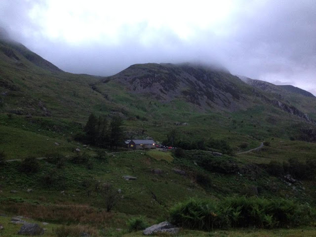

Yr Hafod Activity Centre
I’d brought a selection of cheeses and crackers which I thought would go down well, as the beer and wine continued to flow around that huge table......and it did go down well with the group.
Graeme and Phil were great storytellers, some true and only at the punch line did we find out some were jokes, you never knew which story was true until the end, but the two guys bounced off each other brilliantly and were very entertaining while the cheese and crackers were shared out, and quickly disappeared along with beer and wine.
Talking of sharing, Andy dished out ear plugs for us all. Did he know something we didn’t?
Mark was the first to turn in, and we all soon headed the same way, as once the bedroom lights go out, you’re relaying on your head torch to find your way around without waking everyone up, plus we had a big day ahead.
It had been a long day and once lights were out, and ear plugs fitted I didn’t need rocking. The ear plugs worked a treat, drowning out some of the inevitable snoring, however they did nothing for the “wind” in the room, so maybe a nose clip next time!!!
Saturday
First to rise was Mark, it was daylight but about 5.30am!!!
and I soon learnt that this is a trait of Mark’s, he likes being early to bed, then up early and starts the day with a nice hot brew.
The group as a whole were up slowly and out of bed by 7:30am, eating or preparing breakfast.
It was funny watching different people prepare for a hike.
Andy was busy taping up his feet in the bedroom. Some of the guys were in the communal room packing their rucksacks in a certain way, while I was in the kitchen putting my lunch together along with other guys. Equally Mark was making note that I was extremely organised, as I put my ingredients of salad together from my labelled up box with my name on from the fridge for my sandwich pack up. In my defence, we were asked by Ruth to label up our food before arriving with our names on.
But it was a great opportunity to see what other walkers eat while out on the hills.
Nathan for example was just taking Waffles and a bottle of syrup of some kind, which seemed to be extremely easy, but not my kind of lunch.
I was also looking at kit and clothing and the choices people make during this prep time.
The days walk would start straight out of the hostel door from about 10.00am.
We were now joined by Mark’s son Craig in his midge head net. Our local man’s son volunteers for Ogwen Mountain Rescue Team, and the experienced young man just wanted to keep an eye on his old dad as this would be a stiff climb for Mark who’d had a hip replacement some years earlier.
I didn’t think the midges were too bad, but a net would’ve been handy in the valley.
with rucksack packed, I was ready early, and we seemed to be waiting around for a while before everyone finally assembled outside the centre.
In the car park, with rucksacks donned. Mel insisted we all pose for a group photo before we finally set out. I never did see that photo.
We would be heading for the summit of Y Garn to start with, standing at 3,107ft skirting the northern edge of the body of water called Llyn Idwal, before heading across to the highest point of the day standing just above 1000m Glyder Fawr at 3,284ft and finally Glyder Fach the third peak of the day.
It was good to finally be walking and back to a familiar feel, the pace at this point was very steady as the group stayed fairly close, as we all warmed up.
The weather this morning was overcast but thankfully dry. But the surrounding summits were all shrouded in mist. but at least It was mild, as you’d expect for June.

The group heading for Y Garn at the start of the walk

Jon pictured with a view of the "Devils Kitchen" route right of photo

Looking back at the body of water called Llyn Ogwen and a cloud covered Tryfan to the right of the photo as Phil, Andy and Deb's follow up behind me.
 Phil, Christine and Andy leading Deb's and Ruth at the rear


from left to right, Mark and his son Craig having a chat with Nathan while the rest of the group catch up

The base of Y Garn
The group soon arrived at the point of the climb in earnest, this is now where the group started to open up a little having passed by a wall. As with any large walking group, there will be varying abilities of fitness, and our group was no exception.
The younger lads, Nathan and Dom pushed on, some held back for a while, as we waited for one or two steadier walkers.
Ruth’s partner Graeme held back and stayed at the back to help and encourage the less speedier of the group, while myself and the majority of the group walked slowly up the lower sections of Y Garn.
About halfway up, cloud cover meant we could no longer see the back markers. So we waited.


About halfway up, cloud cover meant we could no longer see the back markers. So we waited.

Myself and Andy below, looking back at our hostel and start point

The back markers of the group were now out of sight

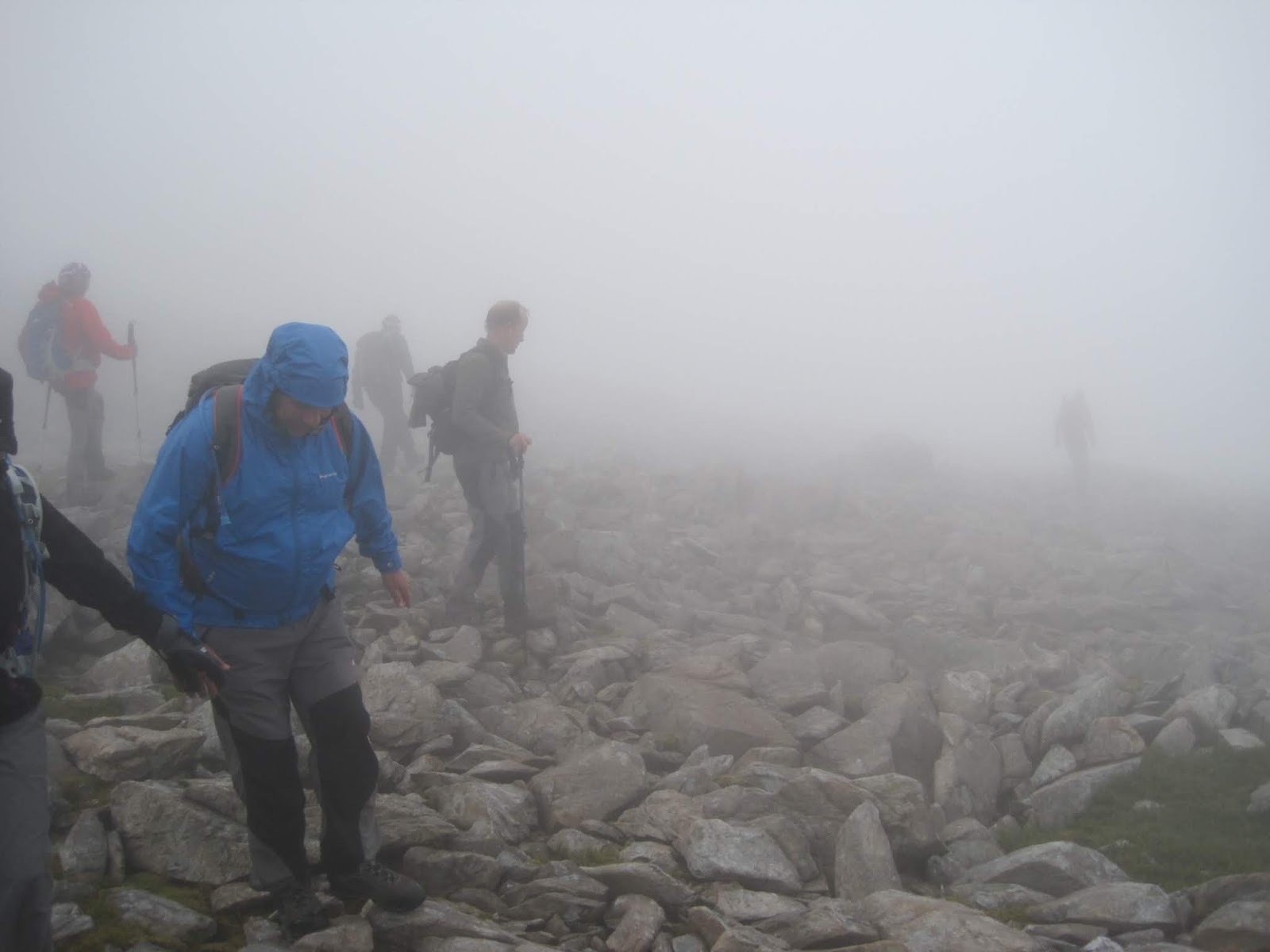
As we were now in cloud, the temperature was much lower, and damp, and standing around too long wasn’t a good idea without layering up. So we continued up the mountain joining up with the rest of the group at the summit shelter.

From left to right, Dom, David, Christine, Andy and Phil in the foreground.
The summit shelter of Y Garn is a rounded low wall, still exposed to the elements but does provide a little shelter from the wind which at 3,107ft is needed. There, the group continued to wait and took the opportunity to eat some lunch as it was about 12.30pm.

Nathan tucking into his Waffles

Mark and his son Craig
Ruth came through the mist with word from Graeme. He was going to stay with Mel and cut their route to a shorter option and descend “Devils Kitchen” as Mel just wouldn’t be able to complete the route comfortably with the group.
At this point we hadn’t reached the 2 mile marker and time was potentially an issue.
So we agreed that was the best plan.
Unfortunately for Ruth, Graeme was carrying all her food in his rucksack, so we all chipped in with snacks for her as we now moved on in the clag in an effort to warm up again.
Descending the wide gentle grassy slope down to Llyn y Cwm, the group spread out a little on the slope losing sight of each other in the mist, but re grouped in the depression at the foot of the scree climb.
From here, it’s a scramble up steep scree, the views were almost none existent. It was slow going and seemed to take an age before the terrain levelled out a bit.


Jon tackling the scree

Andy having a breather on the way up to Glyder Fawr

Nathan and Dom checking out the views?
Eventually we arrived on the spiky rock summit of Glyder Fawr.
Visibility was very poor, and I was pleased to have local walkers with us who knew the mountain, as the terrain was rugged, path less and potentially dangerous, with some huge drops to our north.
However, although I was carrying GPS plus map and compass, it was nice not to need to use them today, trusting the guys ahead of me.
I couldn’t see much of the spiky tops of Glyder Fawr, certainly no views out over the Ogwen Valley as we all negotiated the rocky terrain carefully.


We were soon on Glyder Fach, and although we could just about make out part of the rocky spikes of Castell-y-Gwynt (Castle of the Wind) this is a rock formation of spiky rocks that look similar to a castle.

Glyder Fawr

Jon getting chilly on Glyder Fawr
The full view was just not there for us today, but we soon came across the “Cantilever stone” where a couple of us climbed onto it, and as it was pretty quiet, no one waiting for a photo opportunity so thought it was a good place to sit and have lunch. That ham salad sandwich I made earlier was very nice along with a banana and Jaffa cakes.
During the days walking it was good to get to know a few of the Walking forum members face to face. I was really enjoying the day and the company, pace of the walk was very comfortable. I was pleased to find I was fitter than some of the group, so never felt under any pressure. That’s always a worry meeting a large walking group for the first time, but as I said, I had walked with a couple before today. so knew I could keep up with those guys, but I would never want to hold a group up as I did on the Carneddau in December 2012.


We descended Glyder Fach eastward, picking up a path that would take us to the col between Tryfan and Bristly Ridge, the mist was so dense our navigating leaders got confused temporarily when a GPS was read upside down!!! ........oops
But it was just a momentary lapse of concentration soon corrected, and we crossed a wall by a stile.


Dropping below the cloud base heading east and the waters of Llyn Caseg-fraith ahead.
We made a left turn ahead

Approaching the col between Tryfan and Bristly Ridge

Phil and Christine descending the final mile, her legs felt like jelly she said.
It was a long steady descent and soon we dropped below the cloud base passing Liyn Bochlwyd heading for the A5 and arriving back at the hostel around 6pm.
In just under seven miles we had arrived back at the hostel, where Mel and Graeme were waiting, having had a shorter walk then ourselves.
After unpacking my pack, I joined the group getting showered and changed before heading back to the Tyn-y-coed pub for our evening meal.
The pub was so busy we struggled to get our food orders taken by the staff and as joint organiser with Ruth, Graeme went around the group taking all our orders.
That brought a few laughs as he went around each table.
Drinks and cheese back at the hostel and a night of storytelling from some of the guys.
For most of us, bed was calling before midnight, and a well earned sleep.