Saturday, 13 October 2012

Bleaklow


It was a damp October weekend, and I hadn’t been walking for a few weeks. 
So having read about crash sites in Derbyshire, the B29 Superfortress site on Bleaklow caught my eye as there is plenty of recognisable debris from the crash.
I have seen a couple of crash sites on Kinder Scout, and to be honest, those crash sites could have been washing machines for all I knew, but this one on Bleaklow looked interesting, and made for a good 9 mile trip.


I arrived at the industrial end of Old Glossop early Saturday morning, parking on Shepley street near the bus turning circle. There is plenty of free parking here as it’s situated in a non residential area. Today I was going for a solo walk to find the crash site on Bleaklow. Following the ‘Doctor’s Gate’ path which at one time was a late medieval horse path built between 1494 and 1535 and financed by Doctor Talbot a vicar of Glossop.


The start of the walk in Old Glossop

The route starts right from the bus turning circle as a farm track and takes you passed farmland beyond Mossy Lea Farm, the path then peels off the track running into the Clough following the running waters of Shelf Brook.


Clouds obscure Higher Shelf Stones

The bridge crossing Shelf Brook

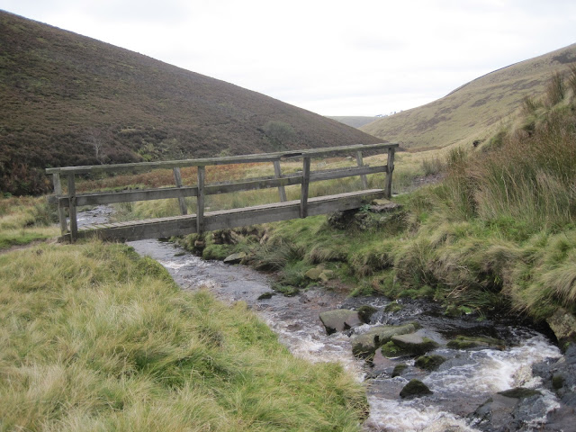
After gaining a little height, the path drops down to the brook and a bridge is crossed.
It’s a bit of a long slog from here, the path disappears in boggy sections and had me standing on a spot, working out my next driest course of direction.
Height is slowly gained and the path changes from the wet mushy bog lower down to a stoney limestone path as I get closer to the end of Doctor’s Gate.


Wet boggy ground in the lower section of Doctor's Gate


The path in a small area is breaking away due to rainfall


Looking back down Doctor's Gate

Bad weather looms over Higher Shelf Stones. Crooked Clough can be seen to the right of photo

My aim was to take a path north east along ‘ Crooked Clough’ before Doctor’s Gate joined the ‘Pennine Way’ the path isn’t well established and the junction is marked by a small cairn, but this is the easiest way to ‘Higher Shelf Stones’ my next target on my route.
The path crosses the brook at the head of the Clough and from here it’s just a short ascent up to the trig point of ‘Higher Shelf Stones’ 621m.


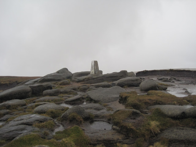
Inscriptions on Higher Shelf Stones

Although overcast all morning, the rain had held off until now. I tried to take shelter as best as I could in order to take a drink and have a snack. It was cold, wet and uncomfortable, so after a quick stop I headed away from the trig. I should have taken a north east compass heading and within a minute I’d be walking amongst the crash site, however I headed north, and completely missed the site.

Hern Stones

Now Bleaklow isn’t called Bleaklow for no reason. It really is bleak up here on a dull overcast day, wild, rugged and can be unforgiving. The tops of this moorland are covered with peat groughs, some as deep as 3m which make it difficult to traverse. Navigation is needed even in fine weather as walking a straight line route of any distance over this landscape is almost impossible. 
Negotiating the huge peat hags was difficult and disorienting as I manoeuvred my way around them and back up to the higher ground, checking my bearings each time.

Passing ‘Hern Stones’  a walker crossed my path, and I ask him about the crash site. Luckily he knew exactly where the site was and pointed me to the spot in the distance. With a thanks, we parted in different directions.

Now my plans had to change as I wanted to visit Wain Stones and ‘Bleaklow Head’ as well as the crash site.
So I continued on my heading north to Wain Stones. Standing at the correct angle, these stones appear to be kissing, which is why they are also known as the ‘Kissing Stones’ from here it’s a NNE heading for Bleaklow Head which is marked by a pile of stones and a pole.


 Wain Stones (Kissing Stones)

Bleaklow Head 633m


From here I returned pretty much on the same route back towards ‘Higher Shelf Stones’ keeping slightly east through thick peat bog and deep groughs, but at least it had stopped raining.

Eventually I arrived at the crash site of the B29 Superfortress bomber. I have to say this is an amazing place, but also a sad place. The first thing I saw were the peat banks, covered with placed poppy crosses. Then the large undercarriage with remnants of rubber still around the wheels. A huge section of wing and many loose pieces of metal lay in the peat.
A stone memorial sits at the site to mark the 13 men killed when the bomber named ‘Over Exposed’ crashed into the moor.
It was flying from Scampton in Lincolnshire to Burtonwood a USAF base, near Warrington. 


I stood for a few moments to pay my respects before leaving the site and making my way on a heading northwest to ‘Dowstone Clough, picking up a faint path along the way.
I crossed the waters of Yellow Slacks Brook before descending Harrop Moss. This path brought me down to the Doctor’s Gate track and back to Old Glossop and the car.
The walk covered 9 miles in just under 5 hours.


The path to Dog Rock


Yellow Slacks


This was a brilliant walk, but I wanted to share the crash site experience with someone. My walks with Andy are too few and far between, so I need a plan...........

Saturday, 11 August 2012

Helvellyn

During our walk on Snowdon back in April, Andy expressed his love of The Lake District and talked in particular about the handful of peaks he’d climbed. One of which he was so keen to show me........Helvellyn, the third highest mountain in the Lake District at over 3,000ft even it’s name is filled with menace, danger, and adrenaline filled adventure. Okay it’s not Everest, K2 or Lhotse, but for someone who until recently only got to the dizzy heights of Kinder Scout it was a big deal for me.


Of coarse Andy would choose the one route he’d done with his father-in-law, climbing up to the ‘Hole in the Wall’ (a stile) from Patterdale before tackling the eastern ridge of Striding Edge to the summit. Then returning on the more northern ridge of Swirral Edge. For a good while I thought Andy was telling me it was ‘Squirrel Edge’ we’d be returning down, then back tracking back to Patterdale, clocking up just over 8 miles.
I completely left the planning of this day to Andy as he expressed his knowledge of the mountain. We were camping at Ullswater Holiday Park, Andy and I had decided our families should meet for the weekend, and spend a little time together.

It was a beautiful warm August morning in the Lake District, and we were all up by 7am. 
As Andy and I would be out for the day, our wife’s had planned a modest lowland walk near Keswick, then some shopping. 
Andy drove the car to the White Lion pub in Patterdale arriving about 9am, I had new boots again today, Meindl Borneo’s this time, believing they were a better fit than the ‘Burma’s’ I’d walked a few miles in them before the weekend and I felt a repeat of Inglebourgh wasn’t on the cards. Andy remembered his boots this time.


We set off from the White Lion back along the A592 and turned left at the cricket ground to follow the lane up by Grisedale Beck to a bridge.

Andy was really excited about today, I think I was more nervous at this point than excited. Andy was talking to me about the Wainwright mountain list, I’d heard of Alfred Wainwright, but didn’t really appreciate what he was about, what he stood for, and I didn’t know he had a list of mountains.

At this moment in time, I wasn’t ticking off Wainwright fells. I’d done Cat Bells with my wife but unfortunately we were heading for Helvellyn only, we could have planned in Birkhouse Moor and Catstye Cam, but this was Andy showing me Helvellyn, he had no interest in ticking off a Wainwright list, but nor was I bothered at the time.

Once at the bridge that crosses the beck in Grisedale, we could see our route, a steady straight path climbing above Patterdale Common. From here the skyline of Nethermost Pike and Dollywagon was ahead, and to the south, Birks and St Sunday Crag. 


The view up to the Striding Edge ridge

Although the air was fresh, as it was early. The forecast was excellent, warm and dry.
Andy wisely elected to wear shorts from the off, but I was a bit slow realising it was going to be a warm day, so zipped off my trouser leg bottoms low down in the Grisedale valley, before the real hard work started. 
I think we over packed for today, carrying waterproofs amongst other gear was unnecessary and made the climb up to ‘The Hole In The Wall’ a much harder one needing more than a couple of stops to get heart rates down and take on fluids.


Andy posing above Grisedale

Looking back towards Patterdale

The Hole in the wall is a mere stepped stile, but it’s not an ordinary stile, because the view from this stile looking into the direction of Helvellyn is fantastic, and the anticipation of Striding Edge.


The mountain holds out it’s two welcoming ridge arms. I hardly noticed Catstye Cam to my right, Swirral Edge looked exciting but my eyes were drawn to Striding Edge.
Andy’s enthusiasm was clear to see, he’d scrambled over Striding Edge before. 
I was excited yet apprehensive, walkers lose their lives every year on this ridge, so I felt a little cautious. 
The ridge was busy with walkers as you’d expect on a beautiful summers day so climbing onto the ridge at Low Spying How meant waiting in a small queue as it was difficult to pass a group of youngsters who were at best sluggish, but mainly static. Andy wasn’t keen on this, he didn’t want holding up and I felt a little cheated out of the early part of the ridge, and missing the Dixon Memorial. 

A closer look at Swirral Edge


Catstye Cam

Having walked the path on the right of the ridge with some gusto, Andy and I finally joined the ridge ahead of the young group, just before we were level with Red Tarn. Walking poles were put away, and I remember Andy stressing to me “three points of contact” I felt very comfortable on the rock, the apprehension disappeared and the whole experience started to feel exciting. 

Yours truly getting to grips with Striding Edge


Patients Andrew

There was no pressure to manoeuvre over the rock from people behind just because of the numbers on the ridge, as they were spread out most of the time, however queues would form at the more challenging spots where extra care was required, as it did when we arrived at the ‘Chimney’ after about a ten minute wait, it was my turn, following Andy. 
Although I could feel eyes weighing up my choice of foot and hand holds, I thought the climb down was smooth and easy enough. another scramble followed and we were soon off the ridge High Spying How and onto the last steep climb on loose rock and gravel which was difficult with now tired legs.


The Chimney


The last steep pull up to the summit


A memorial to Charles Gough sits close to the summit. It’s believed he fell and was killed in 1805. His dog stayed by the body. The body and dog were discovered by a shepherd three months later. The event was later put in a poem by William Wordsworth called ‘Fidelity’

Once at the summit, it was time to have a break. The purpose built stone walled shelter was occupied so we sat on a patch of grass and just absorbed the surrounding mountain view. I couldn’t really recognise any of the distant mountain names to the west, nor could Andy, it didn’t matter, it wasn’t any less beautiful, but probably amusing to anyone listening to us guessing what they might be while we munched on a sandwich.
As I looked at the broad summit, I was trying to imagine the biplane that landed here in 1926, amazing achievement.

Helvellyn trig point 3,117ft 


Red Tarn


Summit break over, my legs had recovered from that last gruelling climb up. My boots still felt good and I was ready to go.
Having traversed along the broad Helvellyn top, we arrived at the head of Swirral Edge along with a number of people, a well established path, but pretty steep initially. Again care was needed negotiating this higher section.


Steady and careful descent of Swirral Edge


Looking back up at Swirral Edge


From here Catstye Cam would have been so easy to summit as a path peels off to its summit, but Andy had other ideas. When we got to Red Tarn, a guy was just getting out of the water after a swim in the freezing cold lake. We thought he was mad, but apparently this ‘tarn swimming’ is a popular pastime, and to be fair, it was quite warm.


Red Tarn and the departed swimmer (right)

From the tarn, it was a short easy walk back to the ‘Hole in the Wall’ I had a touch of cramp in a calf muscle, nothing much but didn’t want any problems up here. Andy and I now returned back tracking down the long straight path which would take us back to Patterdale.

A last look back at Helvellyn


The final mile of just over eight


Once at the A592, it was a short walk along the road which meant passing the Patterdale Hotel. Outside were scores of walkers sat outside drinking in groups. That would have been nice to have had a pint in the sunshine amongst walkers, but we had arranged to meet our families and prepare a BBQ back on the campsite which we did, accompanied with beer and wine and an excellent evening was had by all.


It was an excellent days walking, and I was grateful to Andy for showing me Helvellyn, but I was beginning to feel I needed to look at new avenues to get the fulfilment I needed. I know I’ll return to Helvellyn, walking my own route at some point in the future, and visit the Dixon Memorial.


Saturday, 14 July 2012

Inglebourgh


So today it was Andy’s turn to choose where we were walking. His choice was Inglebourgh, one of the Yorkshire three peaks. We would be walking out of Clapham on a 10 mile route to the 723m peak.


After my boots came apart on Snowdon, I had invested in a pair of ‘Meindl Burma’ boots and I was still wearing them in, but I was having some issues with the fit.

I arrived at Andy’s house on time, but he was late up and rushing around with an arm full of gear. He quickly packed the last few pieces he needed into his rucksack and having thrown the gear in the car, we were soon motoring up the M66 heading for Yorkshire in the beautiful warm July sunshine.

Arriving in Clapham for the start of the walk, I parked in the main tourist car park. 
Both Andy and I started to change our footwear, then Andy realised he hadn’t brought his boots! In the rush to get his gear together, he’d forgotten to put them in my car.
Fortunately he was wearing trail shoes, not the flip flops Andy wears from time to time, so he was happy to walk in his shoes as we'd had dry weather and didn’t expect too much mud, I certainly wasn’t driving back for them. But the boot issues wouldn’t stop there.

We followed a path out of the narrow village lanes by Clapham Beck, a flat easy start towards Trow Gill passing Inglebourgh Cave. It was a busy route with a few folk walking along it.
The sunshine didn’t last long and it was now overcast, but thankfully the cloud stayed high, allowing good views from Inglebourgh summit.

Trow Gill is a wonderful little gorge with a very easy scramble at the top. Andy had no problems in his shoes. The gorge leads to open country at Clapham Bottoms.
We passed Gaping Gill. But due to being held up earlier with Andy’s late packing, and Andy needing to be home early evening, there wasn’t time to detour and explore the entrance to the pothole as we were late starting, which I was a little miffed about.


However, I had more concerns with my boots as we started the initial climb up to the cairn at Sware Gill Head.
My boots really started to feel tight on the sides, possibly with the weight of my rucksack I’m thinking my feet have more spread and the boot fitting now feels too narrow. 

On reaching the summit of Inglebourgh, excellent views out to Whernside in the north, Pen-y-ghent to the east, and great views out to erm.....Yorkshire. I didn’t know Yorkshire very well.
We got a chance to sit down and have some lunch in the summit shelter, a marvellous construction of a good solid wall with extra long stones protruding out providing seating.


Once eaten we set our bearings to NE from the trig point, you can very easily lose them on the very broad peak and end up walking off in the wrong direction. As Andy and I departed the plateau, a marshal, presumably part of Three Peaks Challenge officials in his bright luminous jacket stood by a check point station.
It was a reminder we were joining this well known route for a short while.

Now joining the Three Peaks route down the side of Simon Fell heading East, these paths we’d been on all day were well established ones, stoney and hard but unforgiving if your feet are sore, and my feet were getting pretty uncomfortable.


When Andy and I got to Nick Pott, we took the shorter option turning right, and heading for the limestone rock formations this place is famous for.

We’d been walking for 7 miles now and I really wish I’d forgotten my boots not Andy. We passed ‘Long Scar’ and we arrived at Trow Gill. The pain in my feet was getting too much 
I stopped, took off my boots and had two Paracetamol tablets.
We still had another 2 miles to walk to the car, so after a ten minute foot massage, my feet felt a bit better, until I put my boots back on, no blisters just hot spots under the foot......burning!!!

There is a long old Roman road from here walled both sides, It seemed to take forever to walk that 10th mile, it was the longest 2 miles I have ever done. An important lesson learned. I still have many more in front of me, I'm just hoping they're not all as painful as this one.

I was in too much pain to take any photos, but once the boots came off back in the Clapham car park, they really didn’t feel too bad, and I was able to drive without any problems, reuniting Andy back home with his boots on time. . 

Andy was fine in his shoes, not a lot of mud as we’d had some dry weeks. Just goes to show. The Meindl Burma boots were never worn again as they were returned to the store with a........fault.