Saturday, 30 March 2013

Alport Castles


Still in the grips of winter, there had been another heavy snowfall a few days earlier and I was itching to get out and walk amongst it 

I’d recently purchased some Grivel Spider spikes for about £27 and I was hoping I’d get the opportunity to try them out, they’re not the full crampon, but I was hoping this would be a cheaper alternative.


I was looking for an easy route to walk on without any risks as conditions could be tricky to walk in. It was a bitterly cold weekend and the roads weren’t great so I opted for the Peak District again. 
But this time I was heading to a place I hadn’t been before, Alport Castles.
It was an 11.3 miles walking above Alport Dale.


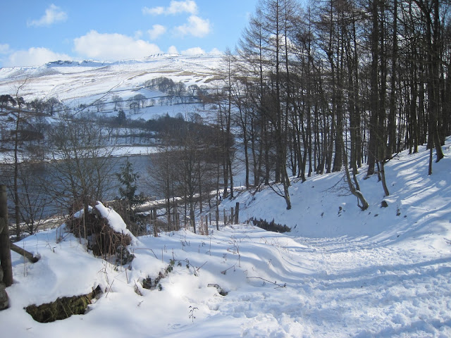
Driving along the A57 Snake Pass is a stunning drive, the sun was out, the sky was blue and the hills were white with snow. As I approached Ladybower Reservoir, looking at the valley full of pine trees reminded me of somewhere like Canada. I had my music high and I felt brilliant, I couldn’t wait to get out there.

I parked along the Ladybower Reservoir at the Bridge End car park. From here I was straight into the woods of Hagg Side and a fairly well trodden path was in front of me. However the hard snow got a little deeper as I gained height and made the ascent just that bit harder.


Once out of the woods at ‘Open Hagg' excellent views of Kinder Scout and beyond could be seen. Although I couldn't see the Snake Pass road though Haggtor Coppice, I could certainly hear the traffic on it.


I made my way towards Woodcock Coppice and a gentle ascent up to Rowlee Pasture.
The wind was bitterly cold, and had whipped up leaving some fields bare while forming deep snowdrifts elsewhere as it became more exposed from here.The walking was varied, from clear paths to deep snow fields.


I decided to try my new Grivel Spider spikes. Probably not the ideal conditions but I thought it will give me an idea of how they perform. I found them difficult to put on under my boot, and not obvious which way round they go. Once on I found them very uncomfortable, sitting in the mid boot, in front of the heel. I also found they moved about no matter how tight I pulled the straps. They were also balling up with snow, so I removed them after a short time as they weren't needed and more of a problem on than off. I was unimpressed.


Whitefield Pits and the route ahead


Looking back at Whitefield Pits


A bit of wind protection needed

I was soon passed Whitefield Pits and looking at the magnificent gritstone cliffs overlooking Alport Castles. These rock formations were caused by huge landslides, leaving these gritstone castle like formations standing alone, the largest of these was named ‘The Tower’ 


The Tower


Gritstone Cliffs, home to Peregrine falcons


The bird hide


The cliffs here at Alport Castles are home to Ravens and Peregrine falcons and a bird hide has residents overlooking the site. Continuing on beyond the high cliffs across moorland I pass a dead sheep, clearly a victim of the recent harsh weather.


The poor sheep shows an unforgiving nature


An exposed landscape 

My target was the trig point on Westend Moor which is just over 500m the highest point of the day. The trig pillar was about the only shelter in this exposed part of the Peak District and was a good spot to have a break as I was just under halfway through the days walk.


Trig point on Westend Moor

I now backtracked a short distance back to Alport Castles through some deep drifts. I then picked up the path heading northeast descending into Fagney Plantation.


Descending down into Fagney Plantation


Its a beautiful little wood, and the snow glistening in the sunshine just made it that bit more rewarding. The woodland path took me to the reservoir perimeter road, from here it was a 4 mile walk along Howden, Upper Derwent and Ladybower Reservoirs back to the car.


It was a great walk in the snow, the weather, although cold was beautiful. I only saw a hand full of people all day. Alport Castles is a stunning little gem, tucked away from the many, to be enjoyed by the few.


Saturday, 16 February 2013

Kinder Scout

Keeping the winter walking going into February I was back out, this time up Kinder Scout.
The route I am taking is from Hayfield, passing Kinder Reservoir, then William Clough up to the Kinder Plateau. I’ll be making my way along the western side of Kinder, passing Kinder Downfall on the way to Kinder Low, skirting Brown Knoll, and around Mount Famine before making my way back to Hayfield.


It was a cool dry February day, It was bright with high clouds. There had been some snowfall the previous week but most of it had melted away, apart from pockets on the plateau.

I parked on Kinder Road, just before Bowden Bridge car park in Hayfield. Plenty of free parking here, and once changed into boots and geared up, I headed out just like the 400 or so protesters did in 1932 as part of a mass trespass to change legislation so the general public had the right to roam mapped access land.


Looking back down the steep cobbled path by Kinder Reservoir


The early stage of William Clough

William Clough is a little adventure in it's self, criss crossing the stream for time to time as the path changes from one side to the other. At some stages a path appears on both sides.

It often strikes me how quiet and peaceful this clough is, with only the running waters of the stream breaking the silence.

Gaining height now, and a sighting of snow above


Looking back down William Clough


Arriving at the crossroads of Wiliam Clough and the Pennine Way


Looking south east along my planned route

It's a bit of a steep climb to ascend this last section of the path onto Kinder Scout, and I had a bit of snow to negotiate.


The snow was pretty solid, so using the existing boot steps, climbing was made easier


Pockets of snow on the plateau path


Arriving at a partly frozen Kinder Downfall


Check out the walkers on the far side for scale


Looking down to Kinder Reservoir from Kinder Downfall


Looking back at the western side of Kinder, and the ground I've just covered


Kinder Low trig point 633m


One of the more deeper snow drifts


Having left Edale Cross, I was now on a path to Mount Famine


Mount Famine


Nearing the end of the 10 mile walk

Saturday, 12 January 2013

Bleaklow


I returned to Bleaklow again in January, having recovered from my Welsh wash out at Aber Falls in December. I was walking almost the same route that I had done back in October. This time I was taking Andy to the crash site along with the other postcard attractions of the Hern Stones Wain Stones, and Bleaklow Head.

Although Aber Falls wasn’t the best experience I’ve had, it was experience gained, and in a funny way it has given me more confidence. 
I also felt it was time to invest in better gear, so a new black Berghaus soft shell jacket was purchased to replace my old red Sprayway jacket. And a pair of Rab Baltoro gloves were bought as well.


It was a bit colder now in mid-winter but still an excellent day. Again heading up Doctor’s Gate from Old Glossop before branching off to Higher Shelf Stones along Crooked Clough. 


Andy taking his own photo's 

Having left the trig point at Higher Shelf Stones, I found the crash site straight away heading NE without problems. Andy throughly appreciated the experience and was quite moved, as I was on my first visit to the crash site.


We were experiencing sub zero temperatures, so Andy and I needed to keep moving in the cold sharp wind. The ground was frozen and much easier to walk than in October, so we soon found ourselves at Bleaklow Head having negotiated the deep peat hags and passed Hern Stones and the Wain Stones.


Sadly this would be my last walk with Andy for some time as a back injury would keep him off the hills for a good while.

Saturday, 15 December 2012

Aber Falls and the Carneddau Range

December 2012, Having joined a walking forum, I was invited on my first meet. 
I felt I needed to open up some more opportunities for walking in other areas of the country and meet more like minded folk. Andy wasn't able to walk as often as I liked, he was also suffering a back injury, so It was time to branch out.  

The route planned was from Aber Falls and covered 7 peaks over 14 miles, climbing from 65m up to 1064m.
Being December, there was quite a bit of snowfall on the higher ground.
The invite was unexpected and all a bit last minute, so I stupidly didn't check the map and the route. although I did have map and compass, I just sat back ready to follow, a mistake I have never made since.

I was nervous meeting these guys. I'd never walked in a group before, I had no real mountain experience unless you count a hand full, no I didn't think so.
First impressions as we all gathered around to say hello?.......an uncomfortable quietness.
Maybe it was the gear I was wearing, cheap by their standards, but hey, it's all I could afford, but maybe they thought I wasn't a seasoned walker, I'm not sure if I was.  

It's a pleasant walk from the car park to the falls, first through woodland, then over scree which becomes quite steep as you get closer to the waterfall.
These guys set out at quite a pace, and I found it a little too fast and quickly found myself at the back of the group along with a guy slightly older than myself.
Just after the scree there is an extremely tricky wet section of rock, right above the falls. A slip here could be fatal, but climbing up wasn't too bad.
I remember one of the lads saying he wouldn't like to return this way, as we scrambled across the wet rock.


The pace continued as we followed the Afon Goch between Llwytmor and Bera Mawr. 
Problem we had was crossing the stream, which was in full spate. so we continued along the path by the stream hoping for a safe crossing point. 
The leading lads would stop and wait further along the path for us, but then would carry on as soon as we almost reached them, so my time to rest and get the heart rate down just saw the gap open up again.

All was going well and I was coping until the time came to cross the stream.
We needed to jump, and I mean jump, full stretch.there really wasn't a narrow section as an option and our route to Bera Mawr was getting steeper while continuing along the path by the Afon Goch.
This was our best option, and probably the safest without walking to the head of the stream, which would have added more miles to the route.

On landing on the far side of the stream, both my calf muscles went into spasm!!!


We were at the foot of Bera Mawr 794m, and the steep climb had only just started.
It was relief when the group decided to stop for a drink and a bite to eat.
I sat massaging my legs, drinking water and trying to down all the sugar foods I could find, hoping the cramp was temporary.
The break was short, rucksacks packed like commando's going into battle. then they were gone.
I found the majority of the six guys were cool, not unfriendly but not very welcoming.
it was my first forum meet, and I wanted to give it a good try.

I pushed on up the mountain, trying not to embarrass myself, and managed to reach the first summit still experiencing sporadic cramp on the steep terrain. 
By the time I reached the summit, the other guys had moved on, so no chance of a chat to discuss my problem.

Walking to the next peak was a lot easier, almost flat, but both calf muscles would go into this painful spasm while stepping over small boulders. To be fair, the senior chap in the group stayed with me, trying to give me some encouragement. 

I was pretty slow by now, the cramp was a real problem, I was really struggling, and by the time I finally arrived at Bera Bach 807m, it was clear as I reached the summit I couldn't continue. 
These guys were stood waiting for me, they had a long way to walk if they were to complete the route, and limited daylight meant a short day. 
plus above the snow line it was full winter conditions so the going would be hard. I was clearly holding them up.

A descent in low cloud would be tricky along the unfamiliar Afon Goch with many concealed drops to catch the unwary out, as the path is a poor one higher up.
However, today the cloud base was high and I felt confident of navigating my way back along the stream as this was the best option with continuing spasms in my legs.
I had a map and compass, so assured the group i would be okay.

Embarrassed, having only met these guys about a couple of hours earlier, and annoyed with myself, for not preparing for this properly I left the group to continue their hike while I dropped back down the valley,
I was relieved the pressure was off, and could sit and rest for a while. Stretching the calfs as much as I could, but I was a little concerned about revisiting that wet slippery rock section above the falls.
On arriving back at the wet rock, the down flowing stream that runs across it was flowing a little more than a few hours earlier, making it a treacherous crossing.
I was so nervous, I slipped on my waterproof trousers and slid over the rock on my arse.

I put the cramps down to a lack of fitness on my part and a fast pace by the group, climbing 1,300ft in a mile from the falls was a tough start.
I messaged the group once I was back at the car, as they'd asked, just to let them know I was down safely.

I have never walked with any of the group since.


10 months later, I was a lot fitter having been in the gym all summer, dropping from 12st to 11st I decided to return on my own and finish the walk I started.

See Aber Falls and the Carneddau Range revisited.