Saturday, 30 September 2017

The Coniston Six

I was looking for a respectable fell worthy of the title 100th Wainwright summit for my next Lake District outing.
The Old Man Of Coniston was an obvious choice. Mainly because back in February 2017, I'd set out to do the Coniston seven, a Lakeland classic, which includes The Old Man Of Coniston, Dow Crag, Brim Fell, Swirl How, Great Carrs, Grey Friar, and finally Wetherlam, But unfortunately the snow and ice that day was hard going as I attempted to do this in reverse, coupled with sub zero temperatures and developing cramp, meant I could only manage to summit 'Wetherlam' before returning home via Levers Water.
So I was keen to return and finish this classic route, and visit the remaining six peaks.


The planned route

The weather forecast for my day was a few light showers early morning then clearing by lunchtime giving clear and sunny skies for the afternoon.

I'd normally be concerned about arriving early enough to get a parking space in the usual tiny car parks and pull in’s around the Lake District, but in Coniston I have found a little spot on Tilberthwaite Ave where you can almost always get a spot for free, rather than pay the £8 charge for over 4 hours in the tourist car park.

As I drove the last few miles into the village, the rain was coming down in buckets, standing water everywhere and I was thinking this is more than a light shower, there was no sign of it letting up. It just looked set in for the day.

I parked up in the village looking out at torrential rain absolutely bouncing off the road. Two guys parked in front of me were sat doing the same. I'd guess we were all thinking the same, we'll wait a while and pray the rain eases off.
But time was ticking by and a time comes when you need to make the decision to go or not as it was now getting on for 10am.
I decided to put my faith in the forecasters and ride out the early wet weather.

I was trying out a new purchase today, a new ‘Kilpi’ shell jacket from Finland and thought this would be a good test.

Once suited and booted with waterproofs on, I finally left the warm dry comfort of my car, and headed out through the village and up the side road passing the Sun Hotel, following Church Beck to the bridge, passing the impressive waterfall.
The path divides here, last time I was here, I crossed the bridge and headed for Wetherlam through the Coppermines Valley and up by the Irish Row cottages. This time I was staying on the west side of the beck and heading straight up the main east route of the Old Man passing Low Water.
The rain was still just as heavy and the air was cool as I started the initial climb.


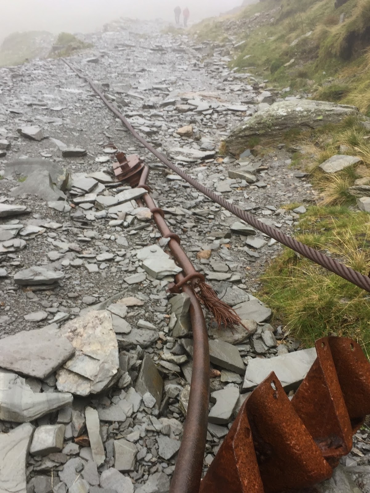
Understandably there were very few walkers to be seen in the cloudy wet conditions, but as I climbed at a slow but steady pace passing derelict buildings, crossing abandoned rusty steel cables, steel frames from the old aerial tramway towers and having passed Low Water, I caught up with two guys from Merseyside, “Jude, as in Jude Law” said one and “Steven as in Steven Gerard” hmm two very humerus lads whom made the last section of a long climb a little easier as we chatted all the way to the summit.


That all important summit shot to mark my 100th Wainwright peak

With the rain now easing off but wind now picking up, the two guys gave me a handshake and took a photo to mark my 100th fell, and continued their adventure on another route to mine. 
It was now 12pm and I decided to take shelter from the now breezy summit of the Old Man Of Coniston to grab a bite to eat and drink behind rocks as a large party of walkers had occupied the main summit base out of the wind.

With high wind and low cloud, I wasn’t going to hang around too long as it wasn’t the most pleasant of spots to enjoy a sit down and snack, so I was quickly packed up and plotted my next course towards ‘Dow Crag’ but at least the rain had now finally stopped.
I was still dry, but my new shell looked wetted out and it also felt heavier so I was thinking possibly not the best purchase I’ve made online.


The view of Goat's Water as I made my way to Dow Crag

The cloud was showing signs of lifting as I could now see Goats Water below to my left having dropped to the col then a short easy climb to this very rocky peak to reach my 101st Wainwright. But I was amazed just how slippery the Rhyolite rock was when wet, as I made a careful but simple scramble to the true rock summit. A quick check of the altimeter on my gps confirmed the summit as there isn’t a cairn to mark the summit here.
The rocky Dow Crag

Looking south on Dow Crag


The sun pops out briefly, a look back at Dow Crag as I return to the col

As the cloud continued to lift I was hoping that forecast I saw of sunshine the night before was finally on it’s way as I left ‘Dow Crag’ to retrace my steps back onto the Coniston ridge, and now aiming for ‘Brim Fell’ 
The walk over Brim Fell along the ridge is easy, a mere hump hardly a mountain yet a Wainwright so now three summits passed and three still to visit.


Looking at my route to come, the path on the right taking me up to Brim Fell. Then walking the ridge from right to left, Swirl How, and Great Carrs, far left is Grey Friar


As I continued the ridge walk leaving Brim Fell behind, I was able to strip the waterproofs off as the day improved with lifting clouds. It suddenly became really busy with walkers. Where had they all come from? Did they all start in that rain like myself?
View of the Coppermines Valley, and Coniston from Brim Fell
It was now feeling warm, a pleasant September Saturday afternoon was developing, as I picked my way over ‘Little and Great How Crags’ by the time I reached Swirl How around 2.45pm the sun was well and truly out.
Swirl How summit, and I was happier than I looked

Looking out north from Swirl How fantastic views of the surrounding fells to the north could be seen, and none more so than of Pike of Blisco and the Langdales where I was just a couple of months earlier.
Someone called this mountain ‘Pile of Biscuits’ and it just sticks in my head when I see it now.


It was just about a 20 minute walk to ‘Great Carrs’ the 5th summit of the day.

But a visit to the nearby memorial south of the summit is a must, where eight airmen were killed in October 1944 while lost when their Halifax bomber crashed in low cloud. A memorial stone in a cairn, plus parts of the undercarriage and a cross marks the spot. I removed my cap and stood reading the inscription for a short time. Respect to those brave men.
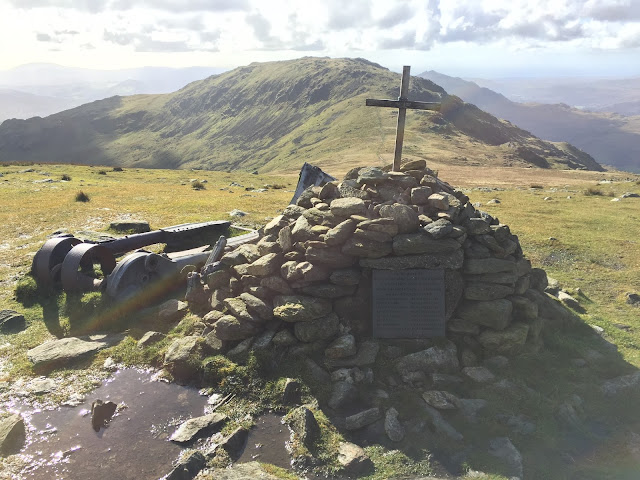
The memorial and Grey Friar beyond

My final peak of the day was ‘Grey Friar’ about 6.5 miles into the walk. Again another short easy walk from Great Carrs on a less well established path, definitely one only travelled on if you are bagging Wainwrights. But once there, some closer superb views of the Scafells can be seen.

Arriving on the final summit, the mountain has two cairns, and having visited both, felt the southern cairn was the true summit according to my gps.
The two summit cairns

It was now 3.40pm and I was about the furthest from the car in Coniston that I’d been all day, so I knew I’d be late back but I felt good, weather was great and I was now on 105 Wainwright’s.

As I made my way back to Swirl How then down the rocky ‘Prison Band’ heading for Levers Water my new shell coat was still drying out hours after the sun had come out, but still damp in the lower half of the arms and waist. Future dog walking coat? I think it was designed for cold but dry conditions as in Scandinavia, not the wet wet weather of Lakeland.

At the foot of Prison Band, I looked back up at the route I’d just descend and remembered the last time I was at this spot back in February, there was deep snow and ice, low cloud, sub zero temperatures and poor visibility.
I was thinking of continuing on to Swirl How at the time but it was mid afternoon I was tired had cramp and with only a couple of hours of daylight left, having not done this route before, I decided to leave it for another day.
I now know it was a good call to make, so with a satisfying smile on my face I made my way down to the tranquil Levers Water.

The path down to the water is one of those that just disappears into boggy wetlands, then reappears on another level, eventually picking it back up again for it to disappear again, so a lot of bog hopping and dodging.

Once by the waters edge there is a good solid dry path on the east side which takes you the length of Levers Water.
From here I continued back into Coppermines Valley following Church Beck passed the YHA.
As I made my way down, I could spot several parties of walkers descending the Old Man like an army of ants all homeward bound. 
The track of the day

I arrived back at the car at 6.15pm. Time to change, and something to eat and drink before heading home, 130 miles away.
Cheeks glowing and a feel good factor of 10 out of 10. An excellent day was had.
11 miles and 4,500ft of ascent in 8 hours, I’m not a fast walker and I believe in a steady pace, I also like to look around at the views often. I’ll forgive the weatherman this time because although the rain was heavy, it did indeed brighten up in the afternoon and I got my reward for that trust.

I hope you enjoyed reading my trip report, and thank you for any comments you might want to make.


Saturday, 11 February 2017

Beaten By The Old Man

I left home at 5.45am for the 120 mile drive to Coniston. Dawn broke on a rather breezy cold Cumbria.
The weather forecast was giving gusts of 50mph and a wind chill factor of around -20 but mostly clear in the southwest of the park, with occasional snow showers. so I was quite optermistic of some good views from up high.

My plan was to bag Wetherlam, Swirl How, Great Carr and if the going was good, Brim Fell and the Old Man himself.

Parking at the Coniston tourist information centre initially, until I realised it would cost £9 for the day, so I quickly moved the car to the nearby Ruskin Ave for free.

I decided to take on Wetherlam first, and set off just before 9:00am crossing the bridge in the village, up to the Sun Inn then following Church Beck taking the route along the Coppermine Valley and Red Dell.

Church Beck waterfall

Looking back down the path towards Coniston

A view of the Old Man Of Coniston, and the YMCA standing at the foot.

The path up the valley follows Red Dell Beck and is a steady climb,

This route was working out well, as the wind forecast for the day was building steadily, so while I was in the valley I got some protection.
At 300 metres the accumulating water flowing off Black Sails and surrounding crags started to freeze, making the path and large areas a skating rink.

With microspikes on, the ice was no longer a problem, but the wind was starting to pick up

Red Dell Beck and a part frozen waterfall

Reaching the snowline at about 400 metres, the bitterly cold wind was getting stronger, snow showers had begun and I was in need of a sit down for a hot drink. and a bite to eat. 
I'd found the going tough through the boggy valley, then ice, and now frozen snow

Slurping hot vimto, and munching a chicken barm with a boiled egg, I sat on a rock, cushioned by my home made mat, looking back down the valley and Coniston water in the distance.

My gloves only came off for a couple of minutes, just to sort my pack out, putting food and flask away, but it was surprising just how quickly my hands started to get cold in the wind. 
At the head of the valley I took the steep route up to Red Dell Head Moss.


The snow surface was frozen but soft snow underneath, so each step would either stand my weight or crash through or it would be the next step, I wouldn't know until the snow was halfway up my shins, having dropped 15cm or so.

Wetherlam summit area was almost down to zero visibility with it snowing and low cloud, I don't think the gusting wind got to 50mph as forecast, but it wasn't far off that speed.


Just to give an idea of the conditions at 760m, on Red Dell Head Moss this was three directions of view, in wind I could only just stand up in and sub zero temperatures, I did wonder what the hell I was doing here all alone, but I was loving the challenge and the small risk.


I believe there are few paths here without snow, but certainly none to be found today, and it did take a few minutes to find the summit as it would appear to have a few lumps and bumps.     The going was much harder than expected and it had taken almost 3 hours to get to the summit.


I knew at this point the plan needed changing, as I'd just got behind time on the route, but rather than return down the valley, I headed for Swirl Hawse along Keld Gill Head on much firmer frozen snow.

This was the first sign of life up here today, footprints before me.


I sat looking up at what I could see of Prison Band at Swirl Hawse having dropped out of the cloud. At this point in the day I had about 2 hours walk (for me) back to Coniston from here which would take the days walk to 8.5 miles. I felt climbing 'Prison Band' for Swirl How and Great Carrs would just take too long in the weather conditions, there wouldn't be a view, and I didn't fancy a decent in the dark, plus I was knackered. That climb up the valley really took it out of me.

So reluctantly I headed for Levers Water while looking over me was a stunning Old Man of Coniston.
A last look back at Church Beck and the Old Man

I was back in the village of Coniston a little earlier than planned, so decided to skip an evening meal, and head the 120 miles home before night fall.

Sunday, 13 November 2016

Marvellous Martindale

In our pursuit of walking the countryside, most of us will find ourselves in circumstances which we wouldn't normally find ourselves in from time to time, and maybe wonder (just for a moment) what the hell are we doing this for.
So I thought I'd share what is now an amusing situation I found myself in while ticking off a hand full of Wainwright fells and a little word of warning about parking.

It was November 2016, I had decided to do a solo walk of the Martindale round.
Having done a little homework on the route and parking for the day as you do, I had decided to park by the Old Church of St Martin at the foot of Steel knotts, on a little patch of flatish grass just off the very narrow road, out of harms way so to speak, just as others had done prevously. The valley was silent when I arrived and not a soul to be seen. It had been a two hour drive from home, setting out well before first light, I finally parked up about 8.50am.

The tracks at the bottom of the photo should have been a giveaway

The Old Church of Saint Martin


The weather was cold but dry, and as I climbed up the path toward Gowk Hill, I looked back down the valley and could see another car had parked up next to mine, which made me think it was a good spot and all would be fine.

The Nab takes centre stage, behind it, is the skyline of the days route I'd be walking.

Looking over to Beda Fell to the left

At some point on the path away from the Old Church I missed the left turn diagonal track taking me up towards Gowk Hill, and instead I was heading for a tree line on a level path,  Having back tracked and not found the right path, I decided to cut through the thick ferns and climb the steep ground to regain the planned route I should have been on. So not the best start to a walk.


Summit of Wether Hill 670m

The day's planned route would include Wether Hill first, then onto the tightly packed High Raise, Kidsty Pike, Rampsgill Head, and The Knott, There are some Wainwright summits you really need  to work hard for, but from this route these four peaks were easily reached with very little climbing involved. I would then go onto Rest Dodd, The Nab, Brock Crags and finally Angletarn Pikes. returning to the valley via Dale Head Farm.


The peace and quiet was temporarily broken as I headed for "High Raise"

Apart from the panoramic views, the walk from Wether Hill to High Raise is a little dull on a track used by quad bikes from the look of it. during this section of walking I felt a slight groin strain, probably due to wading through the ferns earlier.

High Raise summit

From the summit of High Raise, fantastic views of the surrounding fells can be seen, including the Helvellyn range to the west, the Howgill fells to the east, and the Coniston fells in the south west.

Looking back down the valley of Martindale from Rampsgill Head

Rest Dodd summit, and a single poppy is seen on the cairn

After reaching The Knott, and Rest Dodd a little later than planned due to the muscle strain, I had to decide if I had time and the ability to summit The Nab then come back on myself for Brock Crags and Angletarn Pikes and still have daylight to pick up the path at Bedafell Knott taking me down to Dale Head Farm. Alfred Wainwright's guide book suggests it's a difficult path to find, and after my start to the day I wasn't taking any chances.
So I decided to leave The Nab for another day and head for Brock Crags.
 The weather was closing in from the west mid afternoon

 Approaching Angle Tarn 


Having decided to skip The Nab, I had bought myself a little more time, and as the rain was not far away I felt it was a good time to sit, have a bite to eat and enjoy the view of a very peaceful tarn while the weather was dry.


Just as I reached the summit of Angletarn Pikes, the black clouds started to drop below the summits, the rain began to fall, and daylight was fading fast.

 Place Fell

Last light of the day as the rain finally arrived while looking back at The Nab

Not long after passing Dale Head farm, darkness fell on the valley only illuminated by two farm lights.
If you've been to Martindale, you'll know how a feeling of remoteness it is in the dark.
I still had about 2 miles to walk back to the car, I could see the rain was now bouncing off the road through the small beam of light from my head torch, while wishing the lane was a lot shorter.

When I finally reached the car, it was on its own, I could make out the other car parked next to it that day had gone, but couldn't see much else. 
Keeping the head torch and the car interior lights on, I had a drink and ate what was left of the food in my rucksack, after such a long day I was staving and feeling a little wet and cold, I quickly changed out of my muddy boots, and was finally sat in the car dry and warm. Interior light switched off, the landscape was so black. I started the car up, headlights and wipers on and tried to drive off the grass.........the wheels just turned over but the car wasn't going anywhere!!!
I rolled back a bit, tried to drive forward again, but still the same result. I got out and tried pushing, but needed a driver to apply the pedal.
I had an idea 💡 I had some cardboard in the bottom of my boot, under all my walking gear. So I put the head torch back on, emptied the boot (still absolutely chucking it down) and placed the cardboard next to the two front tyres. Yes I managed to roll the car onto them, but they just slid under the car in a crumbling mess after applying a little power.....I was almost back to square one, just further from the road, and I was a little muddier, and wet again. I'm going to need to walk to a farm for help I thought, or I'll be stuck here all night. There wasn't any phone signal in the valley, so calling for help wasn't an option.

It was at this point I saw headlights coming towards me, and like an idiot I ran out into the road in panicking desperation thinking it was a passing car and waved it down, you'd have thought I'd been stuck for days without food or water!!!........it wasn't a car, but a quad bike. 
It belonged to the farmer down the lane who apparently had waited ten minutes after seeing my headlights switch on before setting out to check I was okay.
"Any chance of a push?" I asked
He then began telling me how he'd managed to tow the car parked next to mine out about a couple of hours ago, then shone his spotlight on two huge half wheel shaped divots almost a foot deep in the mud a few feet to my side!!!
And with a knowing look the farmer said "I'll get the tractor" 

Still pouring down with rain I managed to retrieved one cardboard sheet from under the car to kneel on while I connected the tow loop under the car.
The kind farmer returned, roped up and pulled me clear off the grass and back on the tarmac road. I offered to pay the guy but he wouldn't take any money.
Wet, cold and absolutely covered in mud but relieved to be leaving Martindale, I did think to myself what the hell am I doing, but then just laughed and smiled all the way to the YHA that night. You gotta love what we do.

Not all farmers have it in for us walkers, there are some good people out there, so my thanks goes out to the guy who rescued me that evening, I didn't get his name, our meeting was brief in the bad weather ........but a lesson learned for me regarding parking, keep off wet grass unless your parked down hill.

Thanks for reading.